
🚗 TIL: Before GPS was fully operational, Honda built a car navigation system that used zero satellites.
In 1981, the Honda Electro Gyrocator debuted as a dealer option on the Accord. You placed a transparent plastic map over a small CRT screen and marked your starting point.
As you drove, a helium gas-rate gyroscope detected turns: helium flow shifted between two heated wires, creating a temperature difference the computer read as direction. A transmission sensor tracked distance. A 16-bit computer combined both to move a dot across the map showing your position.
Not perfect. Wheel spin and drift compounded, so you could pull over and manually realign. The IEEE designated it a Milestone in 2017 as the world's first map-based car navigation system, 14 years before GPS.
The catch: it cost about $2,746 (nearly a quarter of the car's price). It only lasted one year.
Read more:
spectrum.ieee.org/first-mapbas…
en.wikipedia.org/wiki/Electro_…
global.honda/en/heritage/episo…
#TIL #Honda #engineering #history
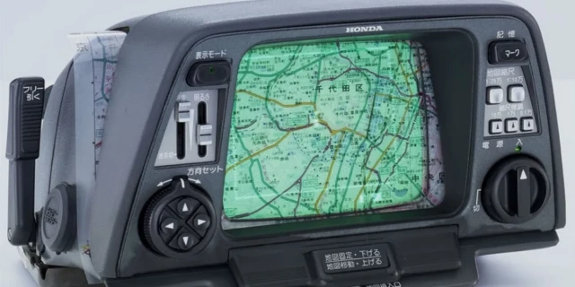
First Map-Based Car Navigation System Debuted 14 Years Before GPS
Released in 1981, Honda’s Electro Gyrocator is now an IEEE MilestoneIvan Berger (IEEE Spectrum)

‘Tad’ Sander 🍉🌻
in reply to jcrabapple • • •David Cantrell 🏏
in reply to jcrabapple • • •Bobby Moss
Unknown parent • • •@DrHyde the phrase you'll want to search is the "Iter Avto".
As the car moved along, a reel of paper was drawn forward by a wire. The main downside is it only worked for one route, and didn't account for detours. 🤓
Bobby Moss
in reply to Bobby Moss • • •@DrHyde oh god, this is a deep rabbit hole. I'm going to stop before I tumble further. 🤣
Here's a cassette tape based system from the '70s.
youtube.com/watch?v=4qqnHtH1RA…
- YouTube
www.youtube.comJon
in reply to jcrabapple • • •David Cantrell 🏏
Unknown parent • • •Colm Ó Donnchadha
in reply to jcrabapple • • •Thorne Lawler
in reply to jcrabapple • • •Angleton’s Bond Car